
Koh Larn Island Pattaya Discover Thailand


Koh Larn Island Pattaya Travel Thailand
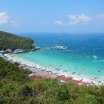
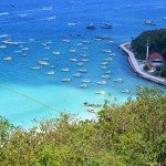
During our recent visit to Koh Larn Island Pattaya I took some photographs from the viewpoint across the bay towards Pattaya. The beach below is called Tawaen beach and is the most popular on the island.
Koh Larn Island Pattaya. Ko Larn (Thai: เกาะล้าน, pronounced [kɔ̀ʔ láːn]) is one of the eastern seaboard islands of Thailand. Ko Lan lies 7.5 km from the nearest shore, Pattaya. “Ko Lan” is the name of the island in the Royal Thai General System of Transcription. It is also known as “Koh Larn”.
Ko Lan is the largest of the “near islands”, off south Pattaya. It is at the southeast end of the Bay of Bangkok, on the east side of the Gulf of Siam. Administratively Ko Lan belongs to the Amphoe Bang Lamung, Chonburi Province.
It is about 4 km in length and 2 km in width. It is a hilly island, covered with low tropical forest; its highest point reaches 180 m where there is a Buddhist shrine. The island has two small villages on it: Ban Ko Lan and Ban Krok Makhan where there are lodgings and restaurants. There are ferries connecting Ko Lan to the mainland. The ferry ride takes about 45 minutes. Ferries leave south Pattaya Bali Hai pier daily from 07:00 to 18:30. The one-way fare is 30 baht. The return ferry leaves Ko Lan’s Na Ban Beach from 06.30 to 18:00. Some local tour operators in nearby Pattaya organize picnic and snorkelling excursions to Ko Lan because there is a relaxed atmosphere and beaches with clear water.
Most of Ko Lan’s beaches are on its west side. Most visited is Tawaen Beach, where there is a small harbor. The length of the beach is lined with small tourist shops, behind which are restaurants whose menus are based mainly seafood. Other beaches are Tonglang Beach, Tien Beach, Samae Beach, and Naon Beach. Ko Lan is inhabited by about 3,000 residents in 1,000 households, mostly clustered around the ferry pier.
Two smaller islands are near Ko Lan:
- Ko Sak (เกาะสาก), a narrow “C”-shaped island with a small bay open towards the north. It is 0.6 km off Ko Lan’s northern tip. Highest point is 33 m. It has a horseshoe-shaped beach in the north. Accommodation is available.
- Ko Krok (เกาะครก), a private island less than 2 km to the east of Ko Lan’s northeast shore. Highest point is 41 m.
Koh Phai, the main island of Mu Ko Phai (หมู่เกาะไผ่), the group of “far islands”, off Pattaya is about 14 km to the west of Koh Lan.